There are 500 microfine miles of pavement called I-90, stretched tight across the broad state of South Dakota from Sioux Falls to Spearfish, along which are aligned plentitudinous marvels, attractions, and wonders. I know this is not a popular impression. That portion of road is elsewhere described as dull, interminable, desolate, and inhospitable. However, I have been over it several times in the decades since it was completed in 1978 and have grown to appreciate its expansive solitudes and quirky sideshows.
This summer I heeded the call of Internet pen pals to meet in the Black Hills and do some motorcycle riding across the Great American Outback. Heretofore I've preferred not to hurry my journeys, taking time instead to savor the experiences, soaking up the addled culture of small-town museums, slowing down to read all the historical markers along the way, and pulling off the road to photograph the frequent vistas, but there was none of that for me this year. I found I could not be gone from work for more than a week and so operated under strict constraint with regard to distances traveled in the time allotted.
The snapshots that follow are snatched out of the whizzing panorama of my vacation, which revolves in my head. Such a combination may in no way be construed as comprehensive. There are a stupendous number of things to see. My itinerary, meager as it was, was impossible from the moment I thought of it, and in the end I missed a lot. Please rather look on this as a sample of wonderment, the merest hint of which validates the effort, expense, and haste required to visit there.
Mon, Jun 11, 2012 06:51 AM CDT — 1.1MB — map
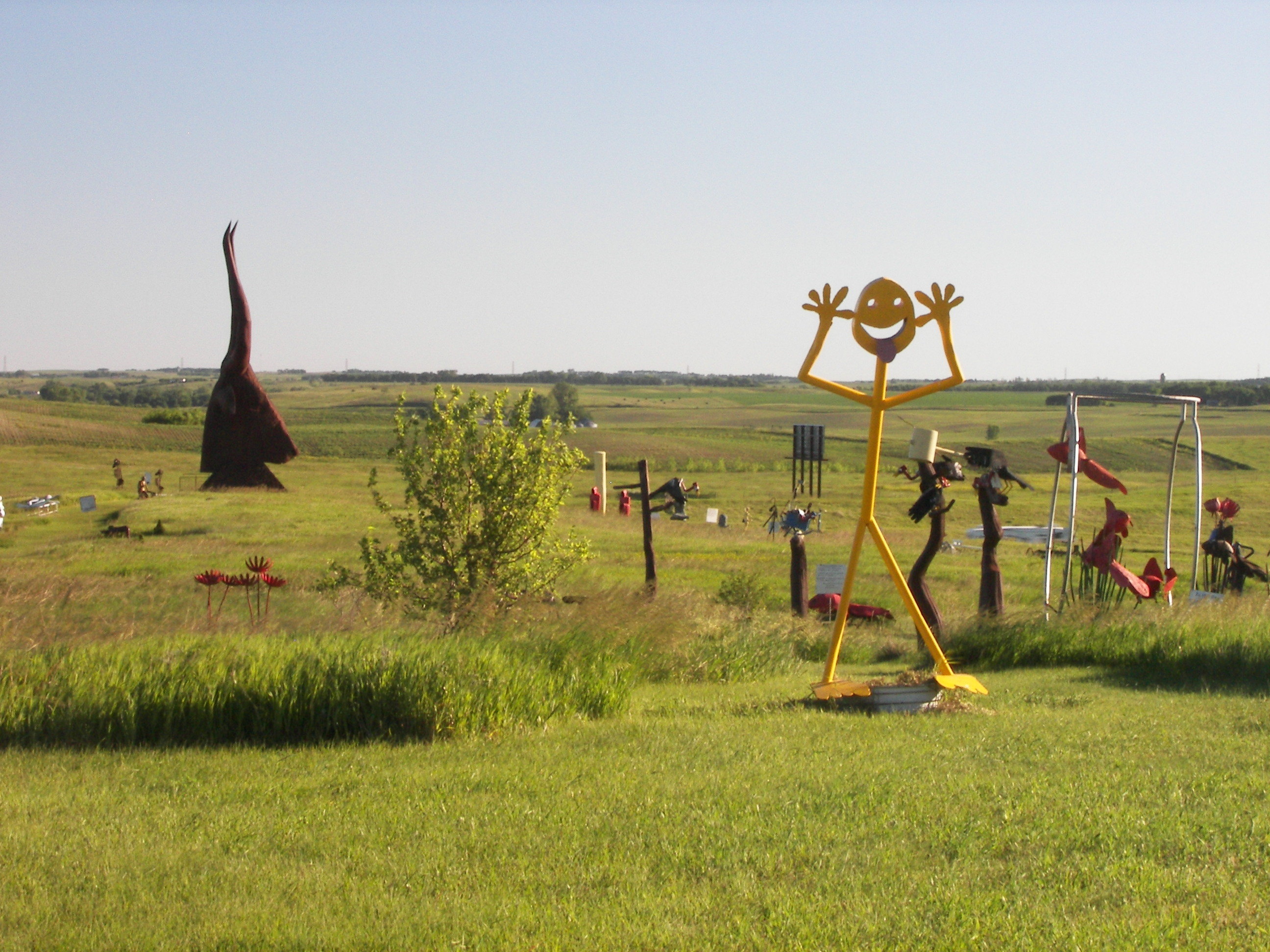
Porter Sculpture Park
First up is Porter Sculpture Park, occupying an interchange 25 miles out of Sioux Falls, where in summer the artist, Wayne Porter, basks in the wind, the sun, and the attention of tourists on their way west to the Missouri River, the Badlands, and beyond. Mr. Porter's fireproof creations are fabricated from scrap metal and mounted on concrete. Most are painted.
The installations appear haphazard. Do not be fooled: (Sightseers don't notice nor care, but photographers do.) Everything is tastefully arranged. In this frame, shot from the first step on the tour path, the one and only bush blots out the view of the neighboring farmstead.
- Kirby, Doug, Ken Smith, and Mike Wilkins. "Porter Sculpture Park, Montrose, South Dakota." Roadside America: Guide to Uniquely Odd Tourist Attractions. 7 July 2012 <http://www.roadsideamerica.com/story/14418>.
Mon, Jun 11, 2012 06:47 AM CDT — 1.1MB — map
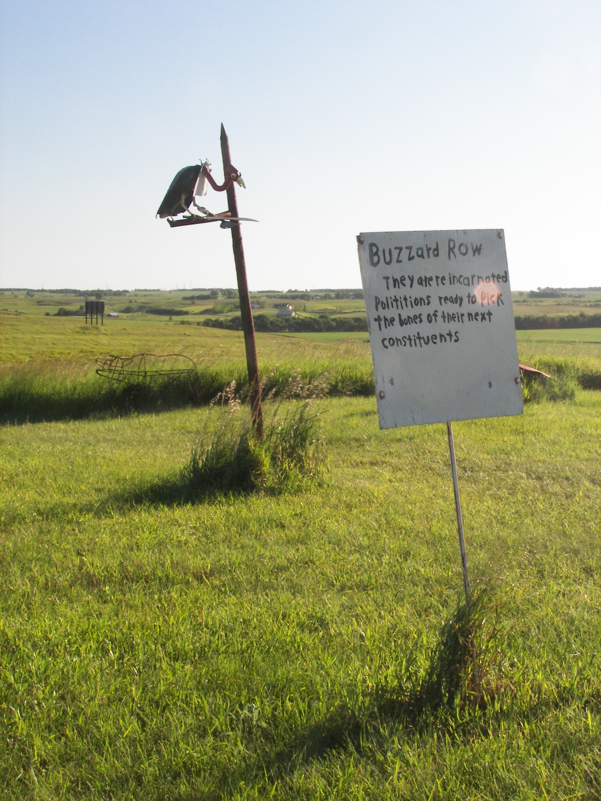
Buzzard Row
Also though the exhibits may seem cartoonish, like those at any good indoor museum many of them come with a sign attached and a sentiment scrawled thereon, which you can take away with you even if you can't come up with one of your own.

Mon, Jun 11, 2012 06:44 AM CDT — 1.3MB — map
Red Fish, Blue Fish
In winter Mr. Porter works in town, building more exhibits. He and his greeter dog spend summers on site, collecting admission.
I'm a little squeamish about taking pictures of art because of the recursion that that introduces to the artist's symbology, but here I couldn't help myself ... and, anyway, even when you pause by the road to capture a panorama — even then — you are interpreting not only God's handiwork but also the craft of the road builder and assorted maintenance crew members, particularly the arborist. This is even true and even most especially true in the western parks ... so I let the chips fall where they may. Be aware then, O Reader, that my titles for Mr. Porter's works are my own.

Mon, Jun 11, 2012 08:14 AM CDT — 1.2MB — map
John Deere Man
Mr. Porter disposes found junk farm machinery in and about his more polished endeavors. Behold John Deere Man whose thoughts burst forth to reality and bear the aspect of action.
I am given to believe South Dakota has received more rain this year than is usual. Thus, the land appears greener than normal. Pasture is good, and the hay crop holds promise.

Mon, Jun 11, 2012 08:19 AM CDT — 1.1MB — map
Apis
The bull, gazing benignly down upon westbound traffic, is made of several hundred railroad tie plates. It is not lit after dark.19 And the Lord said to Moses and Aaron,
2 This is the ritual of the law which the Lord has commanded: Tell the Israelites to bring you a red heifer without spot, in which is no blemish, upon which a yoke has never come.
3 And you shall give her to Eleazar the priest, and he shall bring her outside the camp, and she shall be slaughtered before him.
4 Eleazar the priest shall take some of her blood with his finger and sprinkle it toward the front of the Tent of Meeting seven times.
5 The heifer shall be burned in his sight, her skin, flesh, blood, and dung.
6 And the priest shall take cedar wood, and hyssop, and scarlet [stuff] and cast them into the midst of the burning heifer.
7 Then the priest shall wash his clothes and bathe his body in water; afterward he shall come into the camp, but he shall be unclean until evening.
8 He who burns the heifer shall wash his clothes and bathe his body in water, and shall be unclean until evening.
9 And a man who is clean shall collect the ashes of the heifer and put them outside the camp in a clean place, and they shall be kept for the congregation of the Israelites for the water for impurity; it is a sin offering.
10 And he who gathers the ashes of the heifer shall wash his clothes, and be unclean until evening. This shall be to the Israelites and to the stranger who sojourns among them a perpetual statute.
- Lockman Foundation. "Num. 19: 1-10." Amplified Bible. Grand Rapids: Zondervan, 1987. Bible Gateway. 7 July 2012 <http://www.biblegateway.com/passage/?search=num%2019&version=AMP>.
"The absolute rarity of the animal, combined with the detailed ritual in which it is used, have given the Red Heifer special status in Jewish tradition. It is cited as the prime example of a ... biblical law for which there is no apparent logic and [which] is therefore of absolute Divine origin. Because the state of ritual purity obtained through the ashes of a Red Heifer is a necessary prerequisite for participating in Temple service, efforts have been made in modern times by Jews wishing for biblical ritual purity ... and in anticipation of the building of The Third Temple to locate a red heifer and recreate the ritual. However, multiple candidates have been disqualified, as late as 2002."
- "Red Heifer." 30 June 2012. Wikipedia. 7 July 2012 <http://en.wikipedia.org/wiki/Red_heifer>.
66 And [recall] when Moses said to his people, "Indeed, Allah commands you to slaughter a cow." They said, "Do you take us in ridicule?" He said, "I seek refuge in Allah from being among the ignorant."
67 They said, "Call upon your Lord to make clear to us what it is." [Moses] said, "[Allah] says, 'It is a cow which is neither old nor virgin, but median between that,' so do what you are commanded."
68 They said, "Call upon your Lord to show us what is her color." He said, "He says, 'It is a yellow cow, bright in color — pleasing to the observers.' "
69 They said, "Call upon your Lord to make clear to us what it is. Indeed, [all] cows look alike to us. And indeed we, if Allah wills, will be guided."
70 He said, "He says, 'It is a cow neither trained to plow the earth nor to irrigate the field, one free from fault with no spot upon her.' " They said, "Now you have come with the truth." So they slaughtered her, but they could hardly do it.
- "Al-Baqara 66-70." The Noble Quran Online. 7 July 2012 <http://www.qurandislam.com/coran/trans/?currJuz=1&currPage=10&currSura=2&currAya=62&currTrans=tafsir_en_sahih&isRedirect=false>.

Mon, Jun 11, 2012 08:29 AM CDT — 1.2MB — map
Mallei Maleficarum
Every good graven image requires acolytes, and, those being scarce in Republican-dominated South Dakota, Mr. Porter thoughtfully has provided simulacra.
Sioux quartzite is quarried locally for aggregates used in concrete and asphalt and in these parts imparts a peculiar pink to road surfaces. Not for nothing is South Dakota numbered among the red states.

Mon, Jun 11, 2012 11:31 AM CDT — 1.1MB — map
Al's Oasis
Then it's on to Al's Oasis, a truck stop on the Missouri River, which has matured into a tourist mecca, though in that regard it is the merest foreshadowing of the glories of Wall Drug. I didn't see any acolytes here.
Oacoma, SD, is less than a degree east of 100° west, which divides the arable from the arid lands. In this place it is the river that signals the westward shift from flat terrain to high rolling hills, from row crops to hay.
On this trip I missed recording a fuel stop partway through, so I don't have comprehensive mileage figures. Total distance was about 2300 miles. Over the first 1700 miles mileage by the tankful varied between 27 miles per gallon and 47 mpg. Variance is largely due to my practice of topping off each tank by varying amounts. Overall mileage was 35.9 mpg. However, I did encounter headwinds of 30 miles per hour for the better part of a couple of days. My 30-year-old bike kept ahead of traffic under 75 mph limits, sustaining relative air speeds in excess of 100 mph. Fuel prices varied from $3.579 at Luvern, MN, to $4.059 in the Dells of Wisconsin. Much of the price difference is due to my purchase of gasoline in preference to gasohol where available.
Mon, Jun 11, 2012 03:40 PM CDT — 1.1MB — map
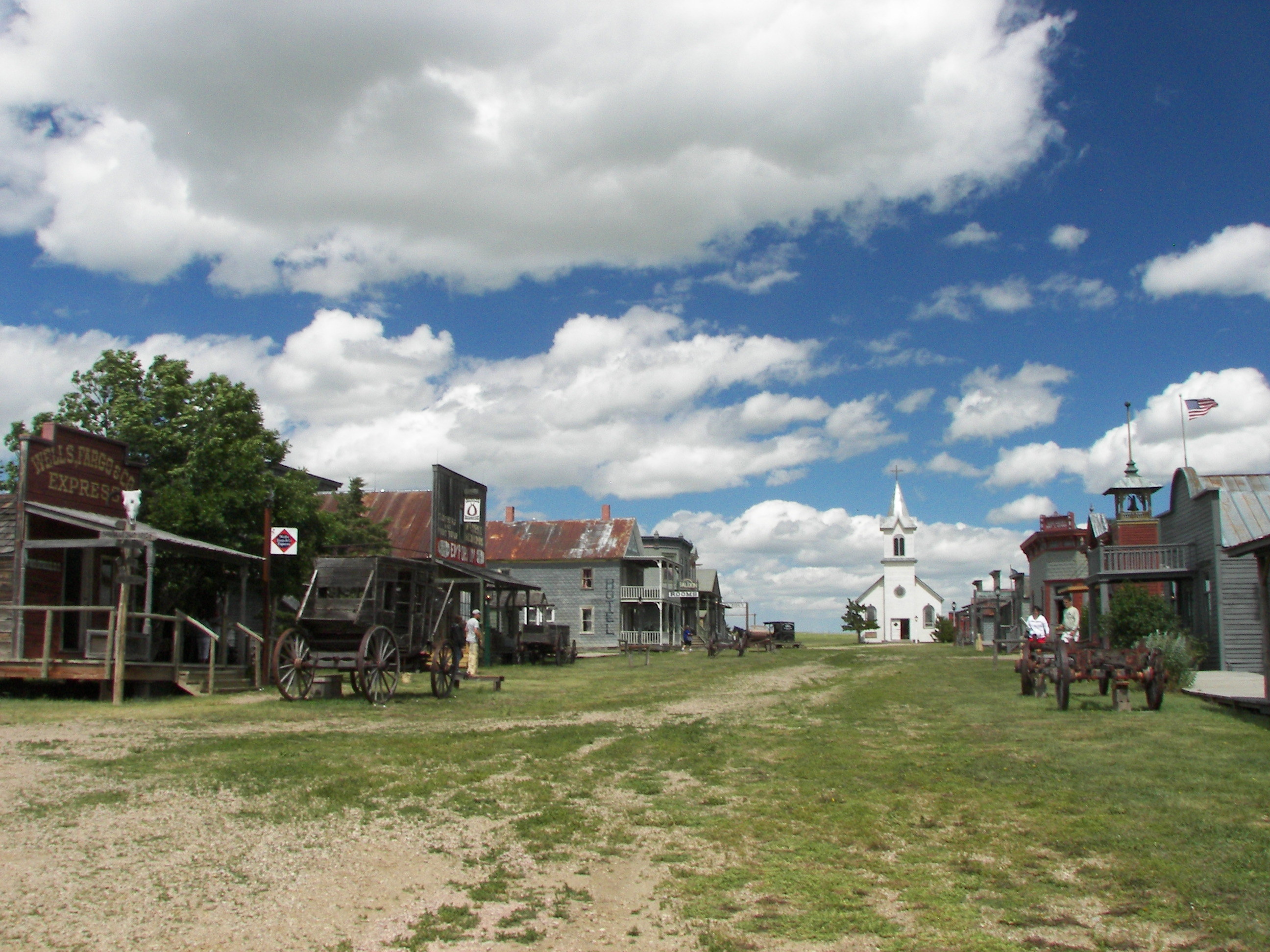
Original 1880 Town
The "Original" 1880 Town is a collection of antique buildings that have been ripped out of their original context and reconstructed together at an interchange 22 miles west of Murdo, SD. They've been modified for child safety and provide the pretext for a self-contained petting zoo complete with costumed wranglers. On the plus side visitors may rent their own costumes to indulge the whole family in an orgy of photo ops.- Kirby, Doug, Ken Smith, and Mike Wilkins. "Original 1880 Town." Roadside America: Guide to Uniquely Odd Tourist Attractions. 12 July 2012 <http://www.roadsideamerica.com/tip/7105>.

Mon, Jun 11, 2012 03:51 PM CDT — 1.1MB — map
Longhorns
These are Texas longhorn cattle (not native to South Dakota).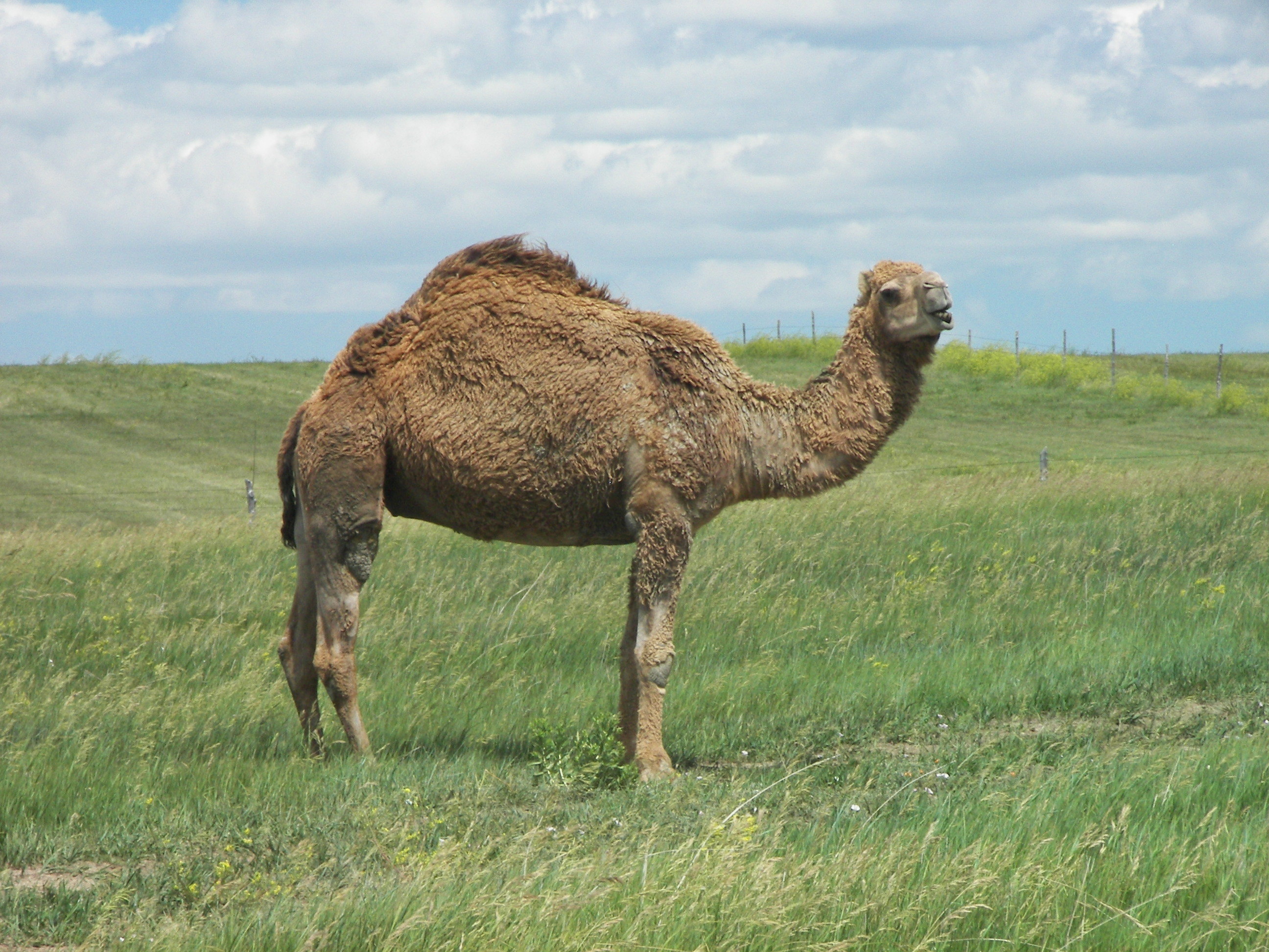
Mon, Jun 11, 2012 03:08 PM CDT — 1.2MB — map
Ship of the Desert
This is a camel (not native to South Dakota either).
Fri, Jun 15, 2012 02:49 PM CDT — 1.3MB — map
Ranch Store
The next outpost of civilization (or last, subject to your point of view) is the Ranch Store at Cactus Flats, SD, on the Badlands approach.- Kirby, Doug, Ken Smith, and Mike Wilkins. "Giant Concrete Prairie Dog." Roadside America: Guide to Uniquely Odd Tourist Attractions. 12 July 2012 <http://www.roadsideamerica.com/tip/3865>.
Fri, Jun 15, 2012 02:56 PM CDT — 1.2MB — map
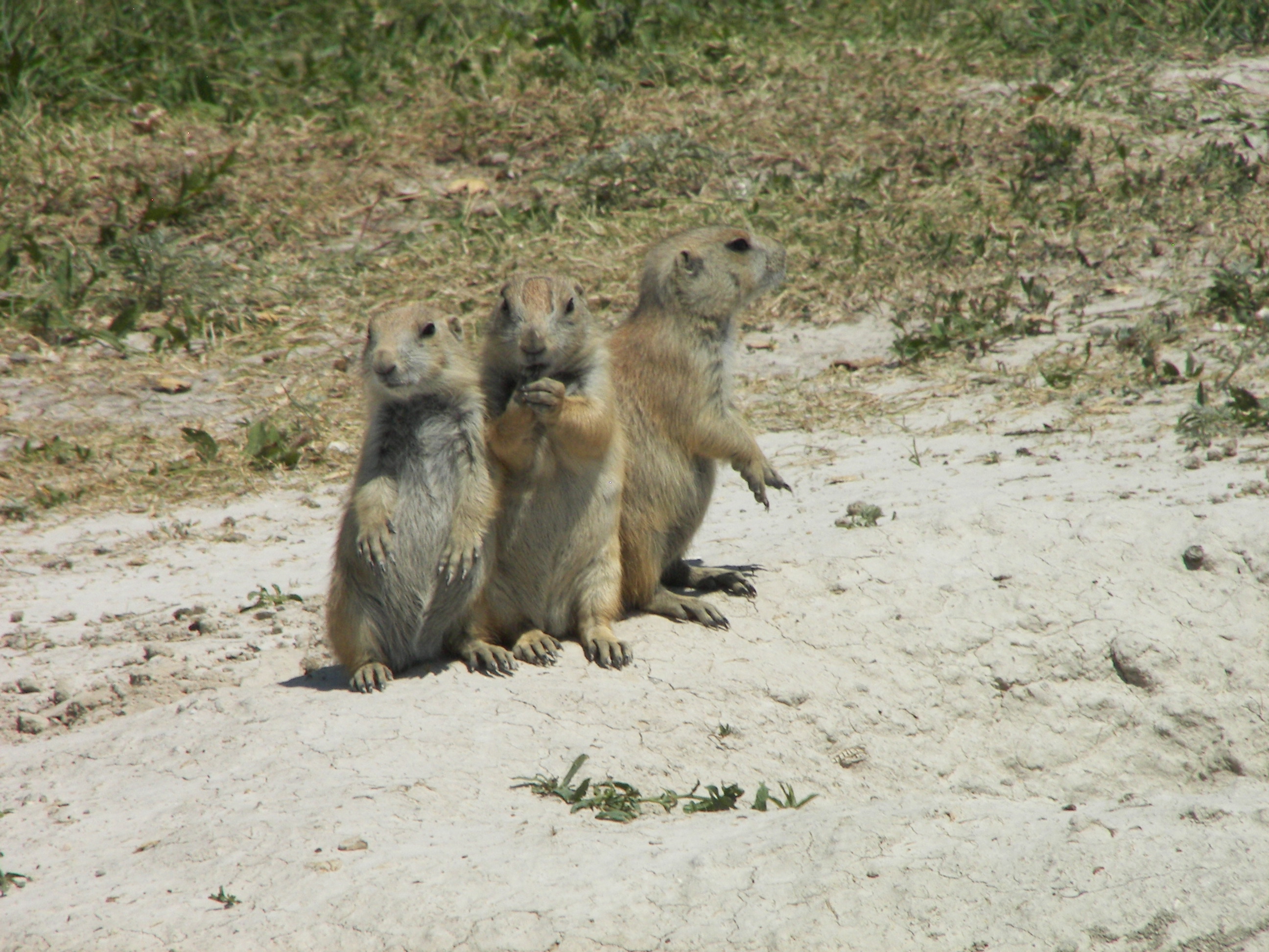
Prairie Dogs
You may well suspect that such a place, unlike a petting zoo, aggressively promotes feeding the wildlife, and indeed they do so. Bags of unsalted peanuts are for sale of course. Elsewhere feeding prairie dogs is proscribed, and fauna there are hesitantly attentive, but here their behavior is fawningly theatrical.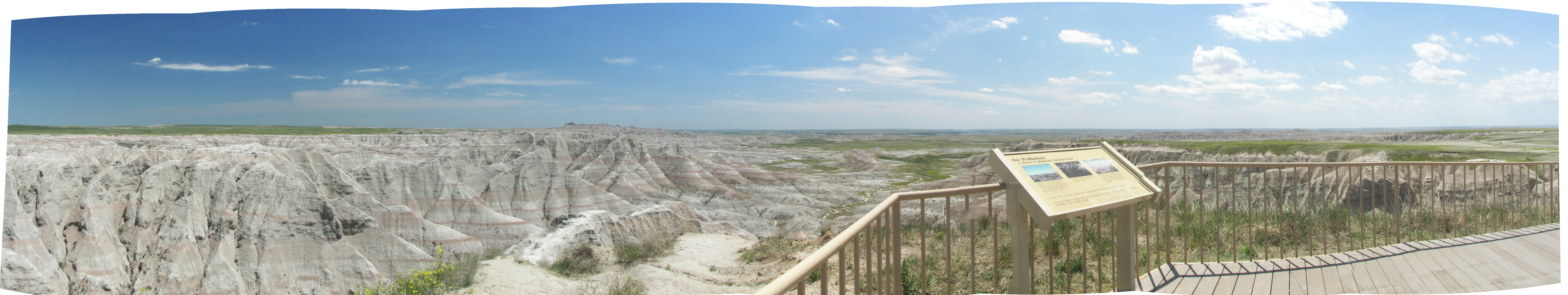
Fri, Jun 15, 2012 01:53 PM CDT — 19.7MB — map
Badlands of the White River
The Badlands are a heavily eroded, broken boundary between grassy mesas and grassy bottom lands.
One sees the free pasture at hand in a wet year and imagines the size of the cattle herd he could run there, but such dreams founder on how hard (and unprofitable) it might be to find the individual cows and their calves, round them up, and remove them all to market in a dry year.
This picture is a panoramic stitch of eight frames performed by the Linux Hugin utility by Pablo d'Angelo.
Fri, Jun 15, 2012 01:20 PM CDT — 1.2MB — map
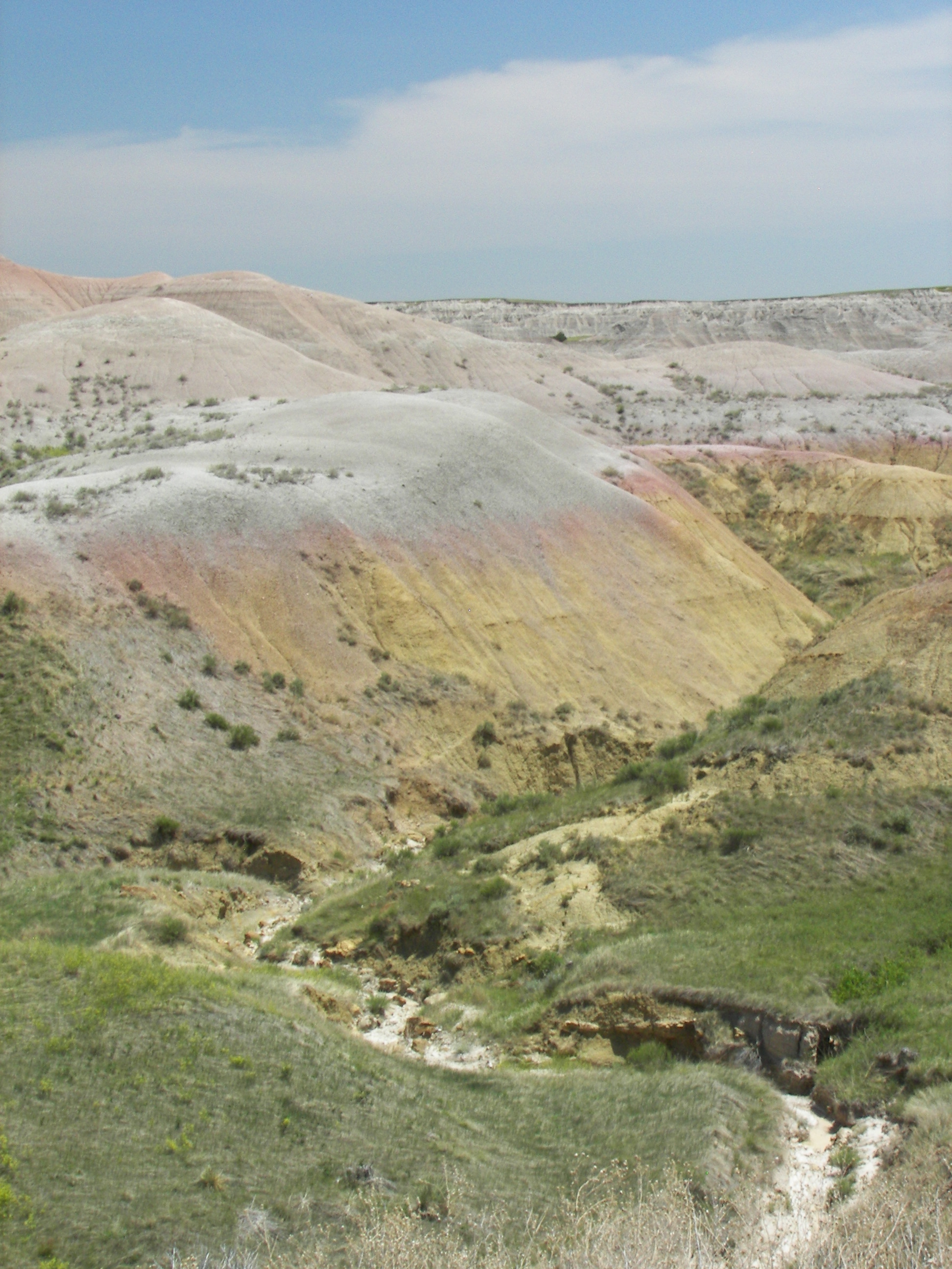
Yellow Mounds
"The sea drained away with the uplift of the Black Hills and Rocky Mountains, exposing the black ocean mud to air. Upper layers were weathered into a yellow soil, called Yellow Mounds. The mounds are an example of a fossil soil, or paleosol.
"Erosion began in the Badlands about 500,000 years ago when the Cheyenne River captured streams and rivers flowing from the Black Hills into the Badlands region. Before 500,000 years ago, streams and rivers carried sediments from the Black Hills, building the rock layers we see today. Once the Black Hills streams and rivers were captured, erosion dominated over deposition. Modern rivers cut down through the rock layers, carving fantastic shapes into what had once been a flat floodplain."
- "Geologic Formations." Badlands National Park. National Park Service. 12 July 2012 <http://www.nps.gov/badl/naturescience/geologicformations.htm>.
Fri, Jun 15, 2012 02:23 PM CDT — 1.2MB — map
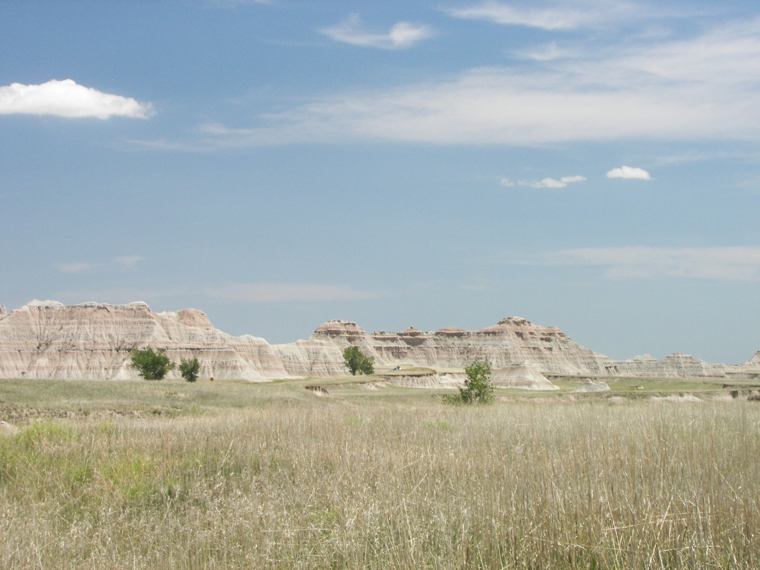
The Wall
Seen from below, the eroded cliffs do look like a wall, hence the name for the populated place on the upper side.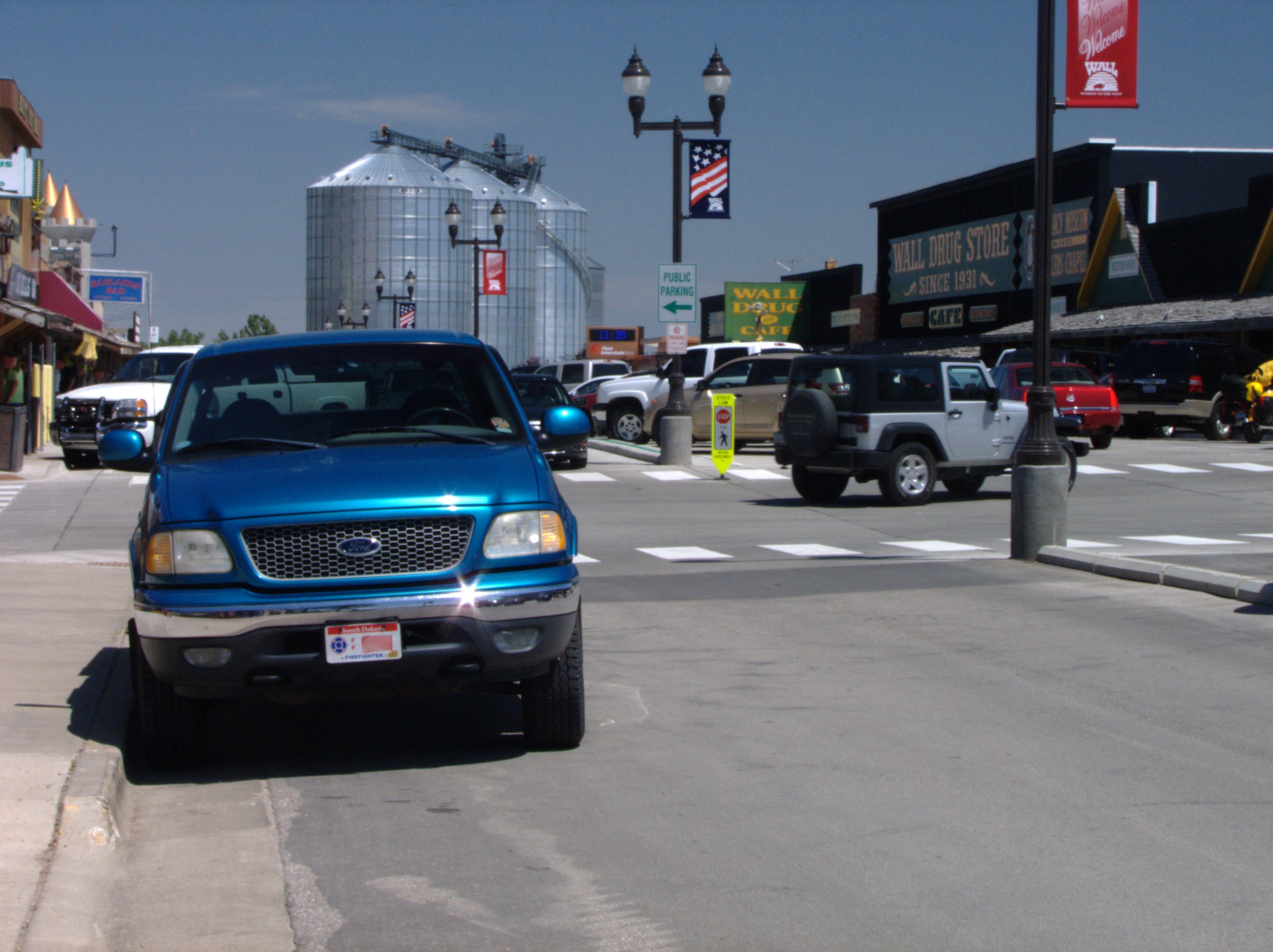
Fri, Jun 15, 2012 12:36 PM CDT — 1.2MB — map
Wall Drug
Ted & Dorothy Hustead bought Wall Drug in 1931.
"Five years, Dorothy, that's what I think we should give to this store. Five good years, and if it doesn't work by then, well, then we'll..."
"Don't worry about then," said Dorothy. "We'll make it go. And just think, Ted, pretty soon that monument at Mount Rushmore will be done, and then there will be an endless stream of people going by. I'm sure they'll visit us!"
- "History of Wall Drug in Wall SD." Wall Drug Store. 12 July 2012 <http://walldrug.com/t-history.aspx>. Rpt. of "Wall and Water." Guideposts 1982.
Mon, Jun 11, 2012 06:20 PM CDT — 1.1MB — map
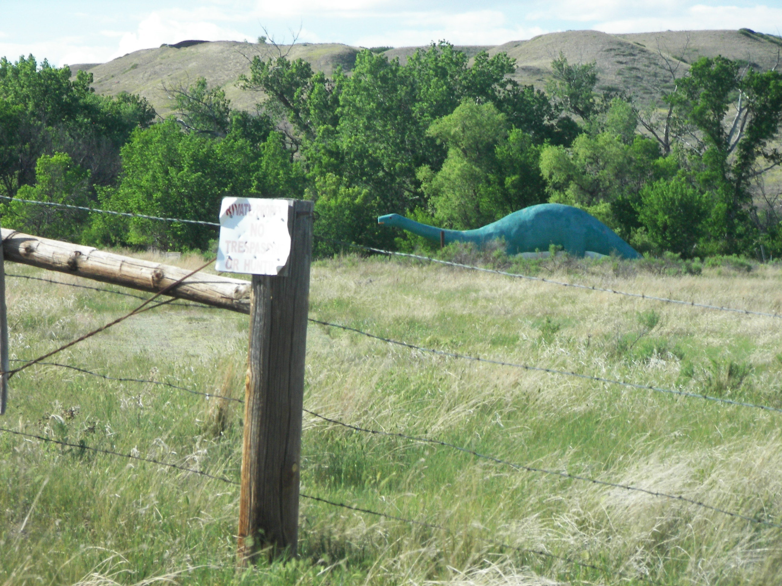
Creston Dinosaur
Creston, SD, is a railroad ghost town located along SD 44 on the banks of Rapid Creek in the Cheyenne River Valley between the bridge over the former and the bridge over the latter.
Wall Drug erected their cement dinosaur when I-90 came through in the late 1960s. Rapid City dedicated their WPA-financed Dinosaur Park in 1936. According to various unauthoritative sources, Creston General Store had theirs up by 1933, making it the first, so apparently it was a good idea — just not the right idea to save the town.
- Kirby, Doug, Ken Smith, and Mike Wilkins. "Dinosaur Park, Rapid City, South Dakota." Roadside America: Guide to Uniquely Odd Tourist Attractions. 12 July 2012 <http://www.roadsideamerica.com/story/10514>.
- ---. "Wall Drug Store, Wall, South Dakota." Roadside America: Guide to Uniquely Odd Tourist Attractions. 12 July 2012 <http://www.roadsideamerica.com/story/2216>.
Thu, Jun 14, 2012 11:20 AM CDT — 1.0MB — map
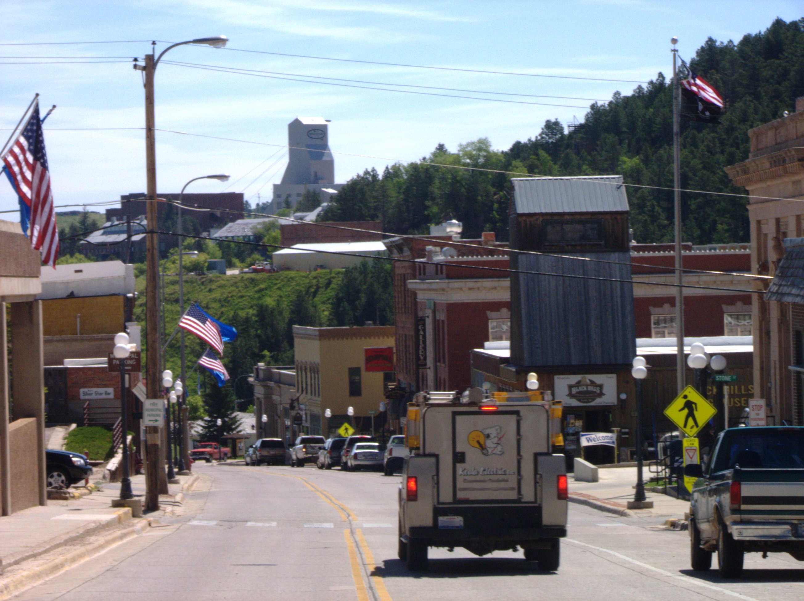
Main Street — Lead, SD
You are looking at why the Black Hills Region is where it is today economically. On the ridge is one of the headframes for the Homestake Gold Mine. Lead (pronounced LEED, a gold lode) is (or rather was) a gold mining town.
Gold in the Hills was confirmed by the Custer expedition to the Sioux Reservation in 1874, which was mounted despite the Fort Laramie Treaty of 1868. The crippled Second Grant Administration could not or would not try to constrain American poaching against the Indian Nation, thus bringing about American defeat at the Battle of the Little Big Horn in 1876 and ultimately retaliatory expropriation of modern day western South Dakota by Congress in 1877.
- "Black Hills Land Claim." 9 July 2012. Wikipedia. 12 July 2012 <http://en.wikipedia.org/wiki/Black_Hills_Land_Claim>.

Thu, Jun 14, 2012 11:37 AM CDT — 17.6MB — map
Open Cut — Homestake Mine
The Homestake operated from its discovery in 1876 until 2002. It yielded (to great expense) 39.8 million ounces, which at spot prices for gold of about $1500 as of this writing would be worth altogether very nearly $60 billion.
This was a deep rock mine reaching eight thousand feet beneath the town of Lead. The Open Cut is a visible surface operation at Homestake one-half mile wide and 1200 feet deep that was worked off and on over the life of the mine. Follow the map link in the caption to the left to see how the Open Cut shaped the town of Lead, its streets, and surrounding highways.
- "24-hour Spot Chart - Gold." Kitco Precious Metals Corporation. 7 July 2012 <http://www.kitco.com/charts/livegold.html>.
- "Homestake Mine (South Dakota)." 11 May 2012. Wikipedia. 12 July 2012 <http://en.wikipedia.org/wiki/Homestake_Mine_(South_Dakota)>.
- "Homestake Open Cut Mine Marker." Ed. Bill Pfingsten. 21 Aug. 2010. Historical Marker Database. 12 July 2012 <http://www.hmdb.org/marker.asp?marker=34673>.
This picture is a panoramic stitch of nine frames performed by the Linux Hugin utility by Pablo d'Angelo.
Experiments done at the Homestake Mine in 1968 were among the first to cast doubt on the Standard Model of Particle Physics (that neutrinos are massless) because the neutrino flux detected was markedly less than that predicted by the Standard Model of the Sun. It is now believed that the Standard Model of Particle Physics is wrong and that neutrinos have some mass, which allows them to oscillate between three states. The Homestake Mine Experiment was sensitive to only one of the three.
"Homestake was slowly filling with water until [2008], when the South Dakota Science and Technology Authority (SDSTA) began pumping it out. The high-water mark was 4,530 feet underground. The water level has been lowered 320 feet since then. The SDSTA is reopening Homestake to the 4,850-foot level, and the National Science Foundation (NSF) is considering a proposal to make Homestake a national underground laboratory, with facilities from the surface all the way down to 8,000 feet underground."
"Late [in 2010], the oversight board of the National Science Foundation dropped out of a planned $875-million underground science lab in South Dakota, leaving the future of the Deep Underground Science and Engineering Laboratory (DUSEL) in doubt."
- Bahcall, John N. "Solving the Mystery of the Missing Neutrinos." 28 Apr. 2004. Nobelprize.org. 12 July 2012 <http://www.nobelprize.org/nobel_prizes/physics/articles/bahcall/>.
- "4850 Level Reached!" Sanford Underground Laboratory at Homestake. 17 May 2009. South Dakota Science and Technology Authority. 12 July 2012 <http://www.sanfordundergroundlaboratoryathomestake.org/index.php?option=com_content&view=article&id=213:4850-level-reached&catid=2:general-news&Itemid=19>.
- "U.S. Science Community Suffers Setbacks Despite Obama's Push for More Investing." Fox News 16 July 2011. 12 July 2012 <http://www.foxnews.com/politics/2011/07/16/us-science-community-suffers-setbacks-despite-obamas-push-for-more-investing/?test=latestnews>.
Thu, Jun 14, 2012 12:28 PM CDT — 1.2MB — map
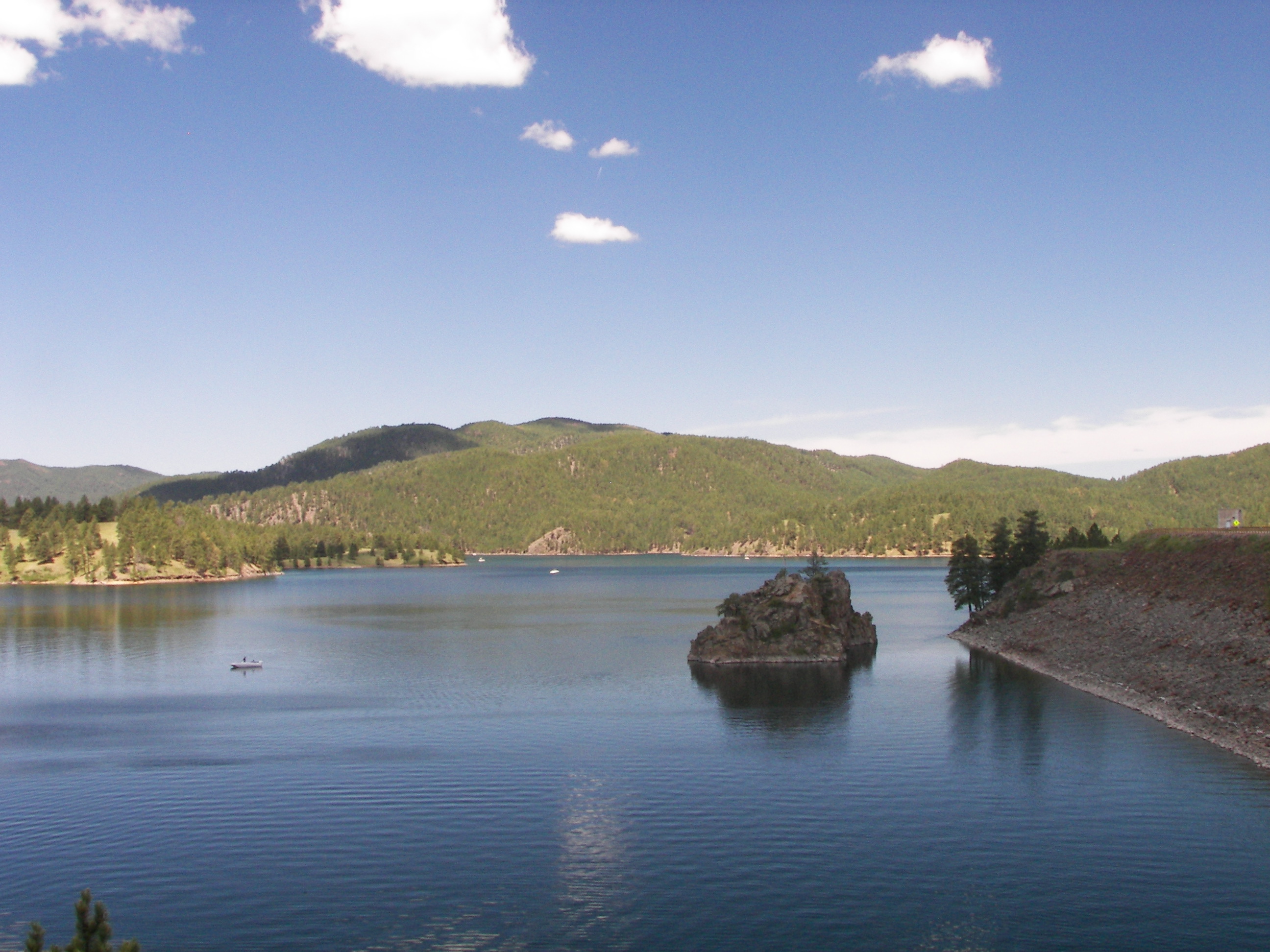
Pactola Reservoir
Pactola Dam was closed in 1956. It inundated the town of that name on Rapid Creek.
As mining declined, the economy of the Black Hills region successfully diversified into tourism, timber harvest, ranching, and national defense.
- "Black Hills." 4 July 2012. Wikipedia. 12 July 2012 <http://en.wikipedia.org/wiki/Black_hills>.
- "Pactola Dam." 6 July 2012. Wikipedia. 12 July 2012 <http://en.wikipedia.org/wiki/Pactola_Dam>.
Thu, Jun 14, 2012 02:22 PM CDT — 1.1MB — map
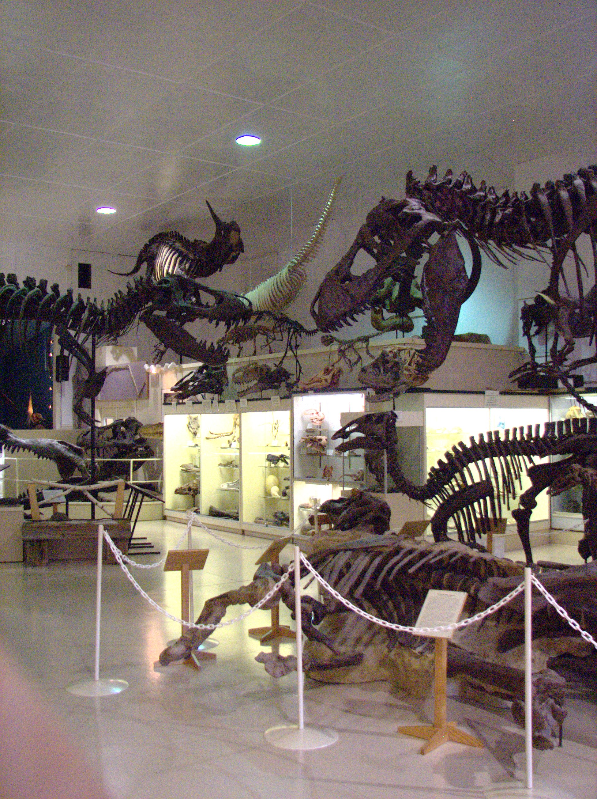
Black Hills Institute
For example, they have converted the old Hill City Auditorium into an exhibit hall crammed full of models of the carcasses of extinct reptiles exhumed by the Black Hills Institute among others.
"BHI is a private corporation specializing in the excavation and preparation of fossils, as well as the sale of both original fossil material and museum-quality replicas."
- "Black Hills Institute of Geological Research." 14 Mar. 2011. Wikipedia. 13 July 2012 <http://en.wikipedia.org/wiki/Black_Hills_Institute_of_Geological_Research,_Inc.
You shall not muzzle the ox when he treads out the grain.
- Lockman Foundation. "Deut. 25: 4." Amplified Bible. Grand Rapids: Zondervan, 1987. Bible Gateway. 13 July 2012 <http://www.biblegateway.com/passage/?search=Deuteronomy+25&version=AMP>.
Wed, Jun 13, 2012 03:03 PM CDT — 1.3MB — map
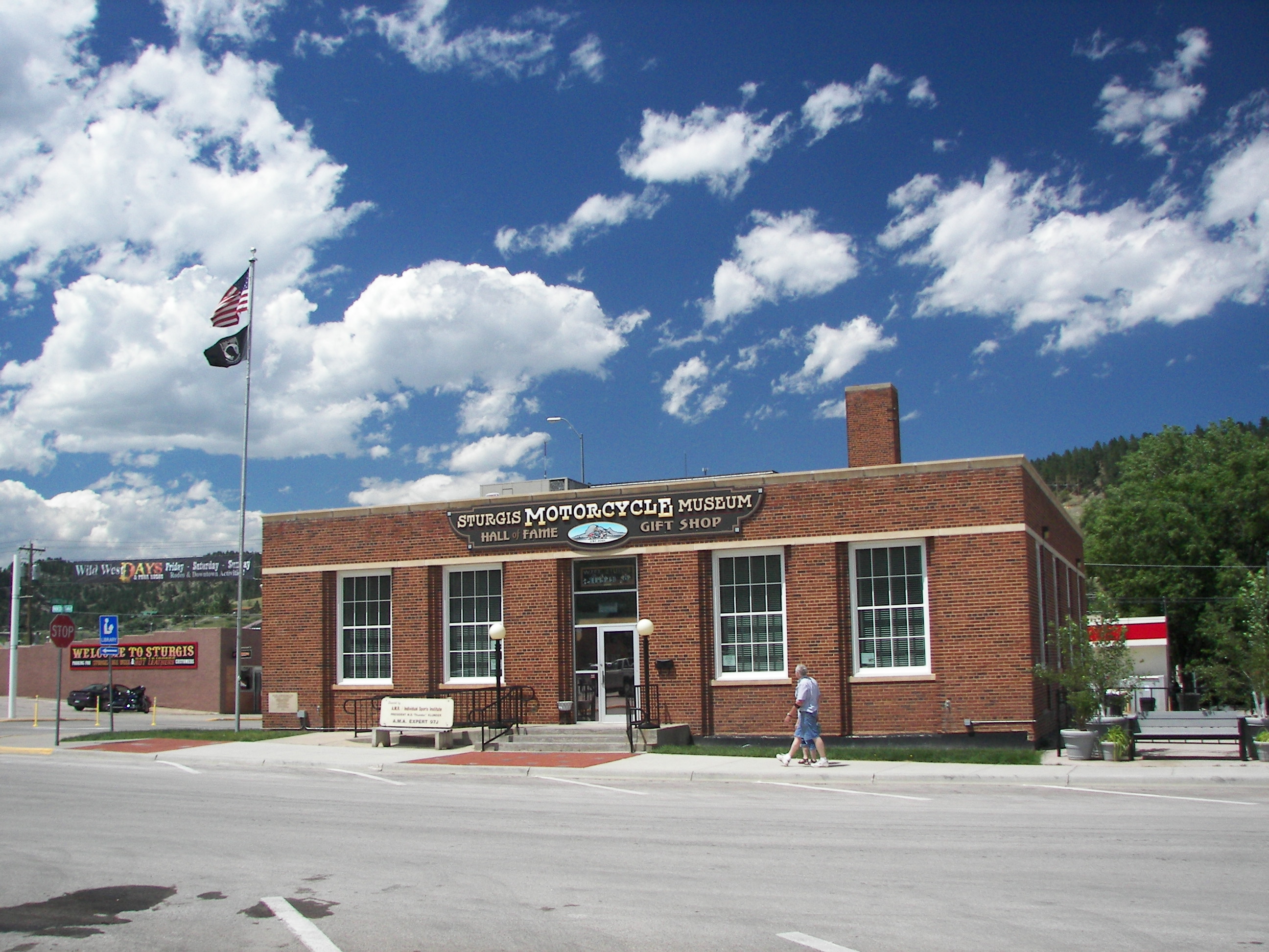
Motorcycle Museum and Hall of Fame
Sturgis, SD, is the epicenter of a motorcycle rally that regularly draws more than 400 thousand to the Black Hills Region. The rally has been held annually from 1938 to the present with a hiatus during WWII. Its economic contribution to the area is greater than $800 million.- Elliott, LaNaya. "70th Sturgis Motorcycle Rally Statistics Compiled by the City of Sturgis and the Rally Department." Online posting. 8 Feb. 2011. Black Hills State University. 13 July 2012 <http://www.bhsu.edu/StudentLife/Living/ResidenceLife/SturgisRally/RallyNews/tabid/11232/articleType/ArticleView/articleId/3453/70th-Sturgis-motorcycle-rally-statistics-compiled-by-the-city-of-Sturgis-and-the-rally-department.aspx>.
- "Sturgis Motorcycle Rally." 5 June 2012. Wikipedia. 7 July 2012 <http://en.wikipedia.org/wiki/Sturgis_Motorcycle_Rally>.
Sturgis is not alone among towns in the Black Hills having store fronts that are occupied seasonally only during the rally. That this is the optimal use for older buildings is curious.
Wed, Jun 13, 2012 01:49 PM CDT — 1.3MB — map
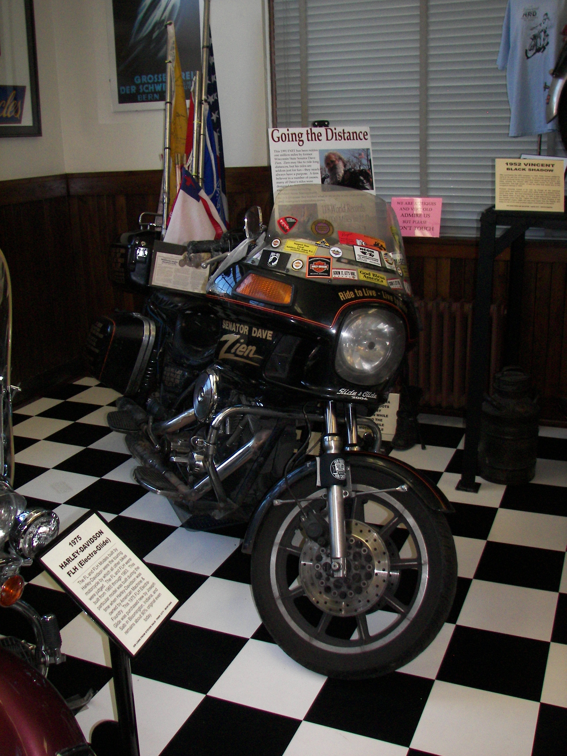
Dave Zien's 1M Mile Harley
The Motorcycle Museum at Sturgis houses unique exhibits such as this 1991 FXRT Harley-Davidson that was ridden a million miles by a single owner, Mr. Dave Zien, who served as Assemblyman and Senator in the Statehouse in Madison, WI, from 1988 to 2007 and used it to travel on business and participate in a series of Iron Butt rallies. The bike was retired in 2009. Harley-Davidson traded him a new one for it and donated it to the Sturgis Museum.
- Sanfelipo, Tony. "First Million Mile Harley-Davidson." Born To Ride News. 5 May 2009. 13 July 2012 <http://www.borntoride.com/new/wordpress/2009/05/05/first-million-mile-harley-davidson/>.
Thu, Jun 14, 2012 09:34 AM CDT — 1.2MB — map
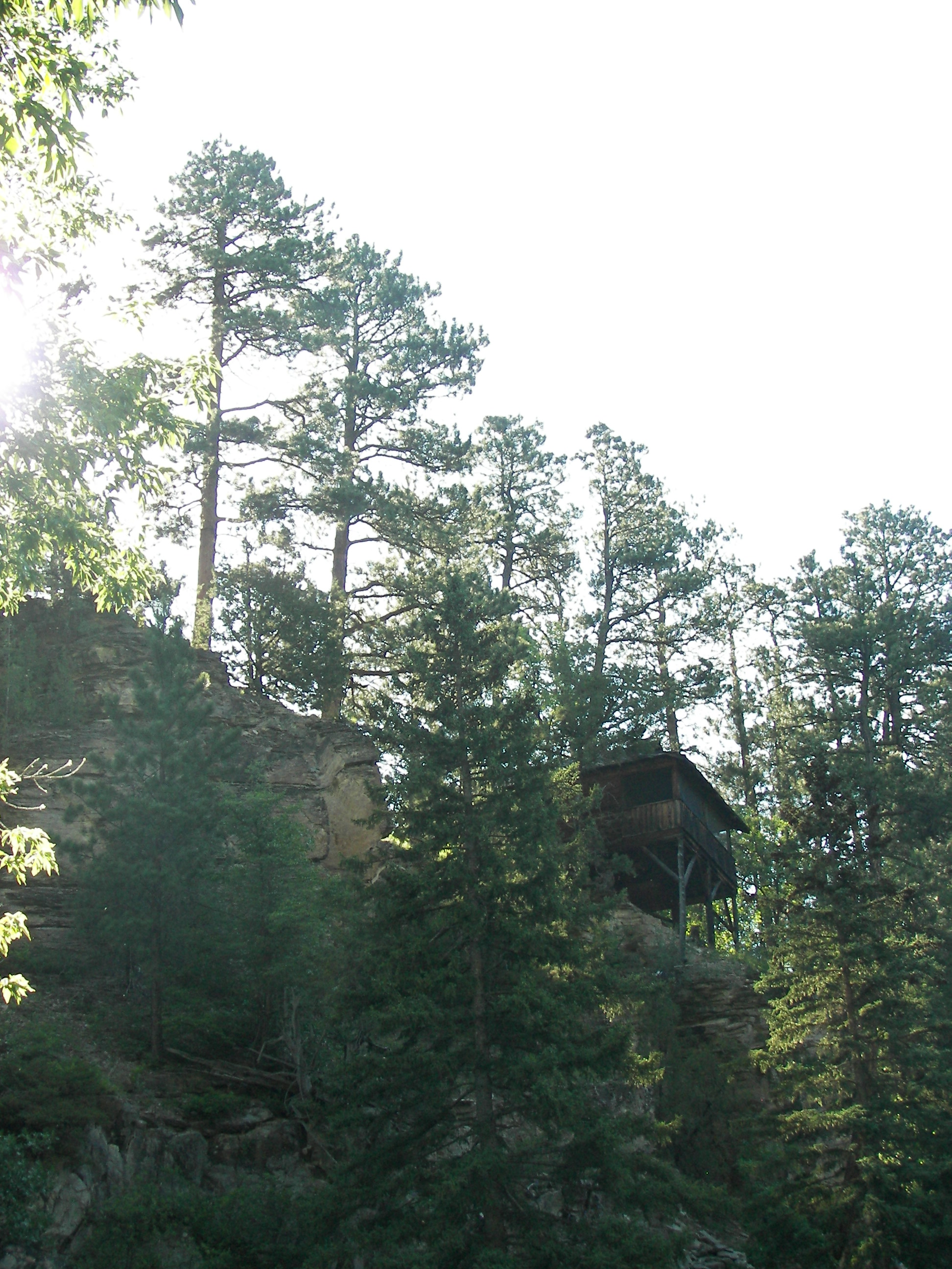
Rimrock Lodge Cabin
During our sojourn in the Black Hills we stayed at Rimrock Lodge in Spearfish Canyon. Three of our troup occupied this cabin perched on the canyon wall. When the rest visited, they made us stand by the door on the landward side.- "Our Story." Rimrock Lodge. 13 July 2012 <http://www.rimrocklodge.com/History.html>.

Thu, Jun 14, 2012 09:42 AM CDT — 1.3MB — map
Rimrock Lodge Dining Room
The back part of the kitchen and dining room is the original 1913 prospector's cabin.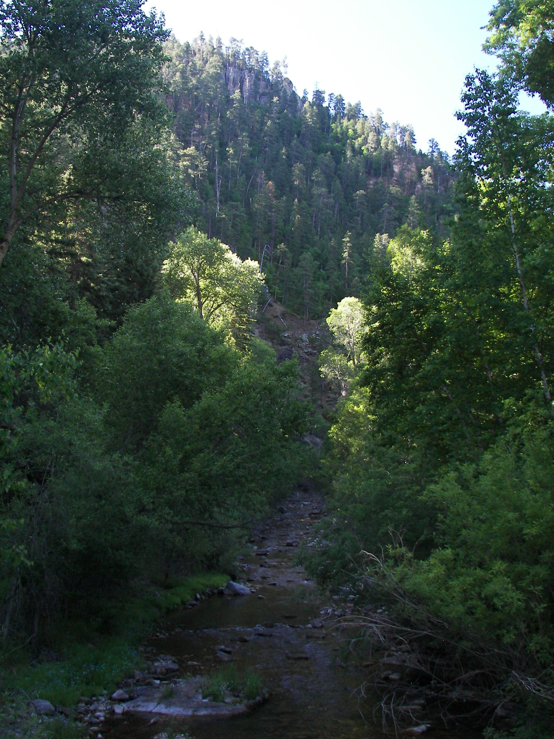
Thu, Jun 14, 2012 09:40 AM CDT — 1.3MB — map
Spearfish Canyon
There is a 35 mph parkway through the canyon, which is popular with bicyclists."Peter Norbeck (August 27, 1870 – December 20, 1936) served as the ninth Governor of South Dakota, and as a United States Senator."
"Norbeck made a number of contributions to South Dakota's tourism industry. He encouraged the development of the Iron Mountain Road in the Black Hills. He brought sculptor Gutzon Borglum to South Dakota and convinced presidents Calvin Coolidge and Franklin D. Roosevelt to provide federal money for the carving of Mount Rushmore. Norbeck also pushed for the development of Sylvan Lake, Needles Highway, Badlands National Park, Custer State Park, and Wind Cave National Park."
- "Peter Norbeck." 10 July 2012. Wikipedia. 13 July 2012 <http://en.wikipedia.org/wiki/Peter_Norbeck>.
Thu, Jun 14, 2012 05:04 PM CDT — 1.4MB — map
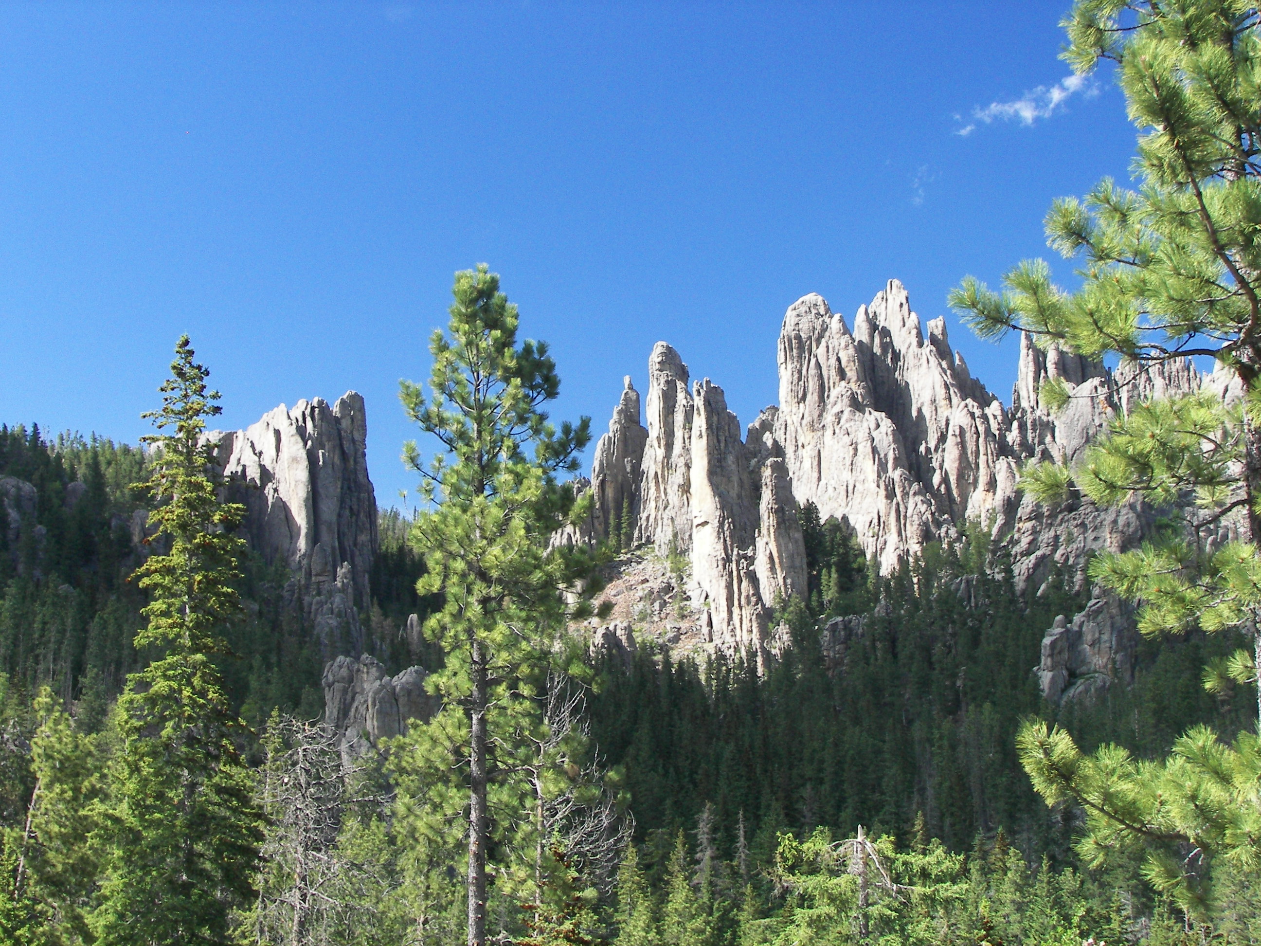
The Needles Highway
There are roads nearly everywhere in the Black Hills. There are roads even into otherwise inaccessible areas such as The Needles south of Mount Rushmore.
- "Needles Highway." Google Maps. 10 July 2012 <https://maps.google.com/maps/ms?msid=202461316251652938297.0004c4727fda626ce1a39&msa=0&ll=43.80827,-103.500824&spn=0.2324,0.441513>.
"Curving between towering granite cliffs and ponderosa forests, the Needles Highway was another brainstorm of Peter Norbeck. He searched the Harney Range for routes that would provide 'the grandest views' — a road to engage the senses in a masterpiece of engineering.
"In 1919, the route Norbeck mapped out was, to conventional engineering standards, impossible to build. When Norbeck asked his engineer, Scovell Johnson, if he could build it, he replied, 'If you can supply me with enough dynamite!'
"Two years and 150,000 pounds of dynamite later, the result was a winding road around through the upthrust sentinels of stone, the Needles Highway."
- "An Engineering Work of Art." Historical marker. Black Hills National Forest, Custer. June 2012.
Thu, Jun 14, 2012 06:46 PM CDT — 1.2MB — map
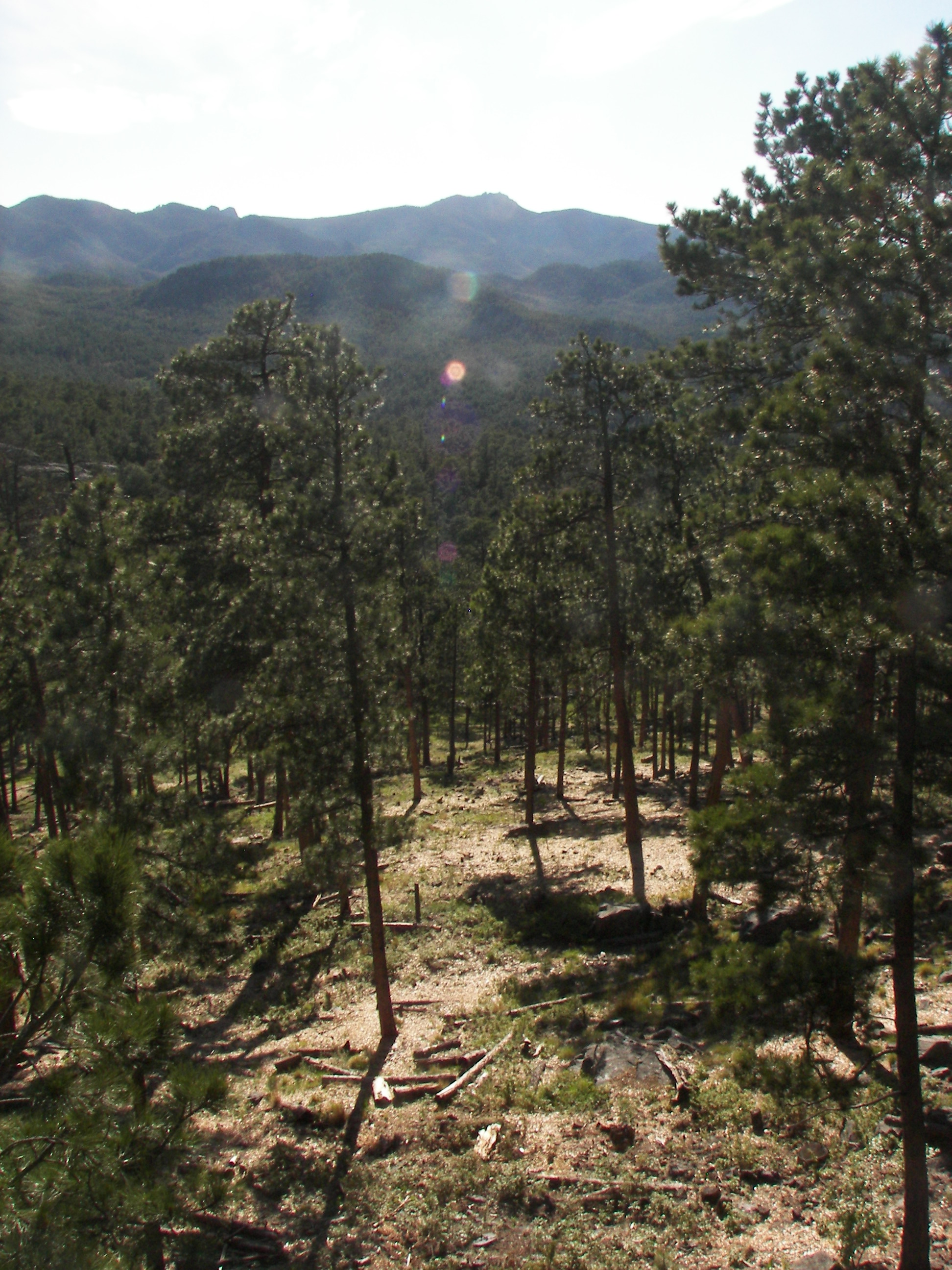
View from Iron Mountain
The Iron Mountain Road starts at the eastern edge of Custer State Park and winds north by northwest through vistas atop open savannas in the rain shadow of the Black Hills to ascend the peak of Iron Mountain by a set of switchbacks. It descends by yet another.
A trip up Iron Mountain Road can be tedious, and some drivers with destinations in mind mistakenly turn onto it. A lady in a minivan accosted a clutch of photographers standing in the middle of the road outside one of the tunnels and asked us whether the road went anywhere. "Please tell me it winds up somewhere — that there's an end to it? How much farther is it?" Obviously she was not with the program.
- "Iron Mountain Road." Google Maps. 10 July 2012 <https://maps.google.com/maps/ms?msid=202461316251652938297.0004c472ac7e992896c3d&msa=0&ll=43.819666,-103.459625&spn=0.232356,0.441513>.
Thu, Jun 14, 2012 07:07 PM CDT — 1.1MB — map
Iron Mountain Road
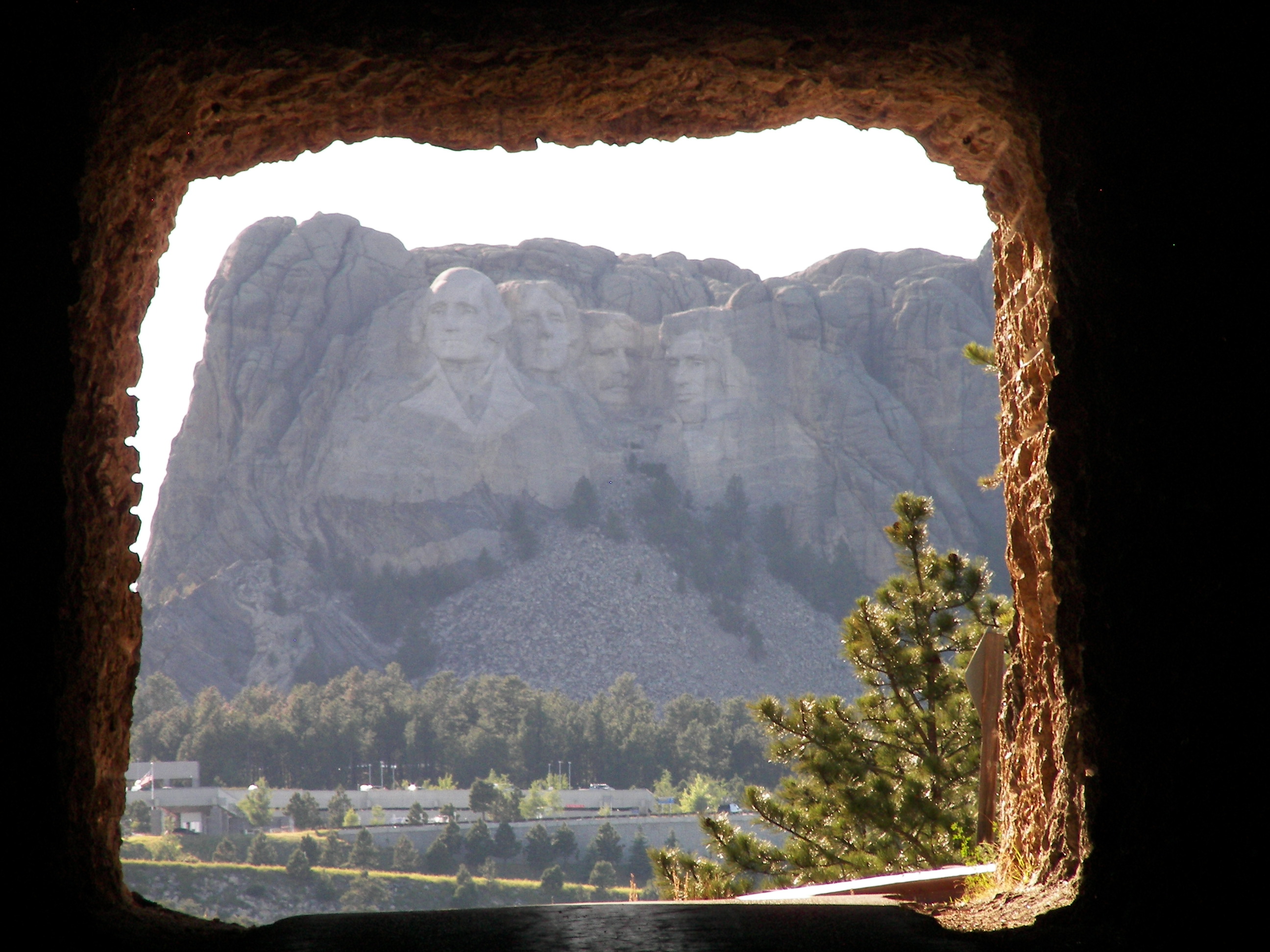
"This highway also required dynamite for the blasting of three tunnels. The tunnels were designed to frame the four faces of the emerging Mt. Rushmore in the distance. That was the easy part.
"Norbeck asked the Superintendent of Custer State Park, C. C. Gideon, to design the road to connect the tunnels. Gideon devised corkscrew spirals that are known as the Pigtail Bridges. The road was completed [during the carving of Mount Rushmore] in 1933 with the help of 16 men.
"Together, these roads linking Custer State Park, the Black Hills National Forest, and Mount Rushmore National Memorial are now known as the Peter Norbeck National Scenic Byway."
- "An Engineering Work of Art." Historical marker. Black Hills National Forest, Custer. June 2012.

Tue, Jun 12, 2012 12:52 PM CDT — 0.9MB — map
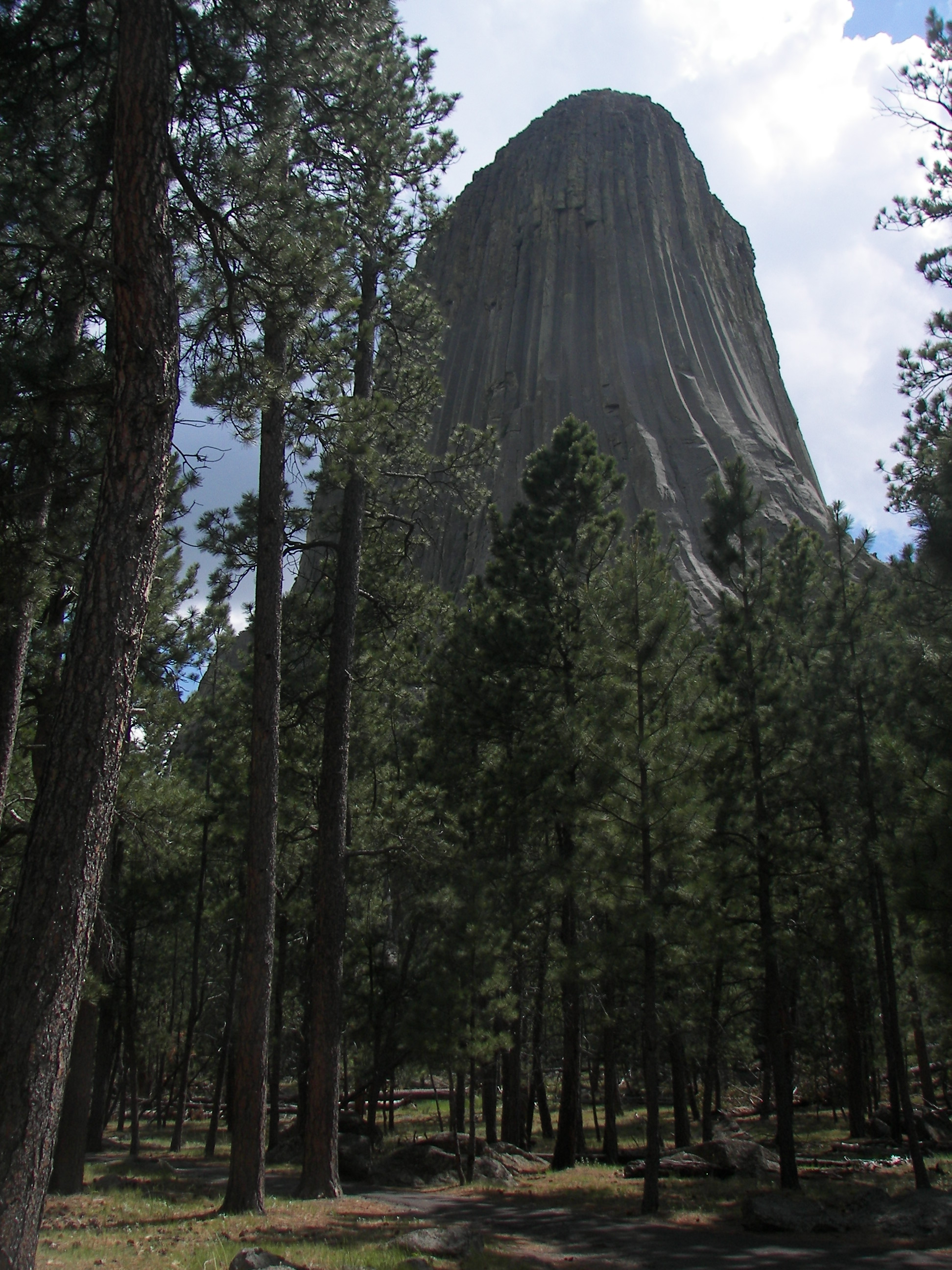
Devils Tower
"About 50 million years ago molten magma was forced into sedimentary rocks above and cooled underground. As it cooled, it contracted and fractured into columns. An earlier flow formed Little Missouri Buttes. Over millions of years erosion of the sedimentary rock exposed Devils Tower and accentuated Little Missouri Buttes. The Tower rises 867 feet from its base and stands 1,267 feet above the [Belle Fourche] river and 5,112 feet above sea level. The area of its teardrop-shaped top is 1.5 acres. The diameter of its base is 1,000 feet."- United States. Dept. of the Interior. National Park Service. Brochure. Devils Tower National Monument Wyoming. N.p.: GPO, 2011. 365-615/80645 Reprint 2007.
Tue, Jun 12, 2012 04:08 PM CDT — 1.2MB — map
Bears' Tepee
"Before the Kiowa came south they were camped on a stream in the far north where there were a great many bears, many of them. One day, seven little girls were playing at a distance from the village and were chased by some bears. The girls ran toward the village and the bears were just about to catch them when the girls jumped on a low rock, about three feet high. One of the girls prayed to the rock, 'Rock take pity on us, rock save us!' The rock heard them and began to grow upwards, pushing the girls higher and higher. When the bears jumped to reach the girls, they scratched the rock, broke their claws, and fell on the ground.
"The rock rose higher and higher; the bears still jumped at the girls until they were pushed up into the sky where they now are, seven little stars in a group (The Pleiades). In the winter, in the middle of the night, the seven stars are right over this high rock. When the people came to look, they found the bears' claws, turned to stone, all around the base.
"No Kiowa living has ever seen this rock, but the old men have told about it — it is very far north where the Kiowa used to live. It is a single rock with scratched sides. The marks of the bears' claws are there yet, rising straight up, very high. There is no other like it in the whole country. There are no trees on it, only grass on top. The Kiowa call this rock "Tso-aa," a tree rock, possibly because it grew tall like a tree."
- I-See-Many-Camp-Fire-Places. "First Stories: Kiowa Legend." Devils Tower National Monument. 1897. National Park Service. 14 July 2012 <http://www.nps.gov/deto/historyculture/first-stories.htm>.
Wed, Jun 13, 2012 04:01 PM CDT — 1.3MB — map
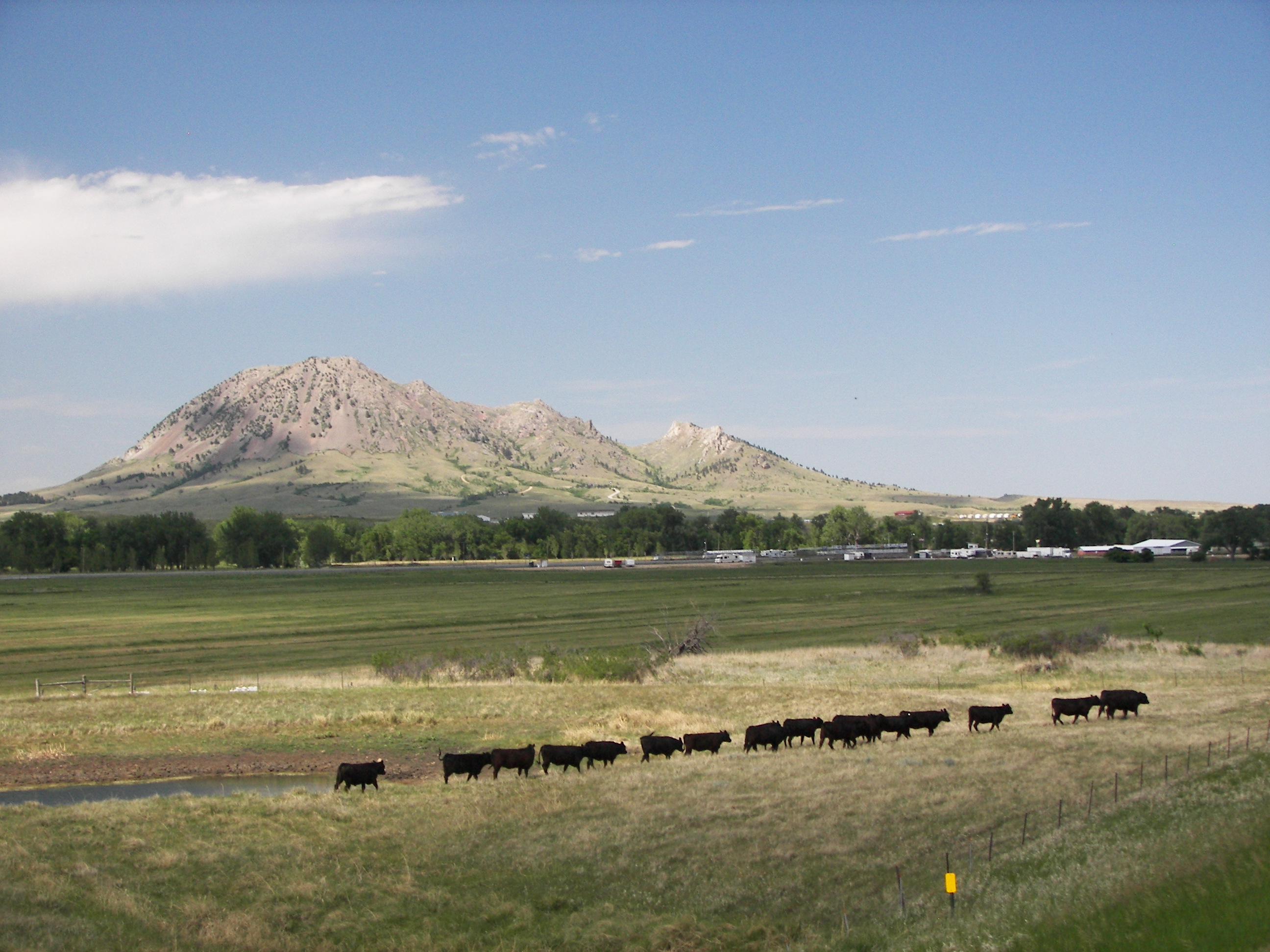
Bear Butte
... so what became of the bears? Apparently, one settled down for a snooze a little way northeast out of beautiful, bustling downtown Sturgis. Whatever you do, don't try to tickle his ears.
Tue, Jun 12, 2012 04:31 PM CDT — 1.3MB — map
Catching the Clouds
The Hills appear black because pines grow on their slopes. The pines grow there and not on the dry plains 'round about because the Hills lift the prevailing winds, cooling them and wringing out excess moisture as rain and snow.
You can see bits of fabric tied to bushes around Devils Tower. These are prayer cloths left by Indians and Wiccans.
Once upon a time there was a sport-touring rider who believed in wearing all the gear all the time. One windy day he visited Devils Tower and decided to walk the paved trail that circles the tower's base. He was especially impressed with the sign warning hikers to beware of snakes and from that point proceeded cautiously. It was a day oppressive with warmth on a global scale, and he had of course worn his Roadcrafter, so, when he came to the north face of the tower, he sat down on the park bench there and dozed off.
- He imagined he had woken atop the monolith on the very tip of the topmost pinnacle. He saw his helmet at his feet tipping back and forth in the expanding winds that blow from that place to every other. Looking farther down, he was surprised to see hunters pursuing wooly mammoths over the plains. He called and waved to them, but he may have seemed like a spirit to them because they ignored him.
- On the second day the earth thundered, and he woke to see horsemen chasing a herd of bison. He called and waved to them, but he may have looked like a devil to them because they did not acknowledge his presence.
- On the third day he woke to see prospectors panning for gold in the streams that run from the mountains, and he called and waved to them, but they did not look up.
- On the fourth day he heard blasting and saw men building roads everywhere.
- On the fifth day he woke to the sound of the jake brakes of the trucks hauling logs down the valleys.
- On the sixth day it was so still that he woke to see fishermen wading in the rivers, and he called and waved to them, but they didn't hear him either.
- On the seventh day a sonic boom wakened him, and he could see contrails in the sky.
- On the eighth day there were hundreds of thousands of Harley riders milling around the tower, and he called and waved to them, but, whether they were too drunk, too deaf, or too preoccupied to wave back, he couldn't say.
- On the ninth day desert gave way to grassland, and he saw ranchers driving cattle there. He called out to them to help him get down — that he was too thirsty to last one day more. Then he thought he heard the voice of a snake inside his helmet, and the snake said, "Jump," but he didn't jump. Instead, he missed his footing and fell. He fell a long time. The sky burned away from purple to black, and the stars all around were driven back by dark energy. He thought how nice it would be to land in his own bed, and then he thought perhaps he did.
He came to himself on the bench by the trail around the base of the tower, looking into a blue sky so deep the tower itself was lost in it. He took out his cell phone, but the battery was dead. "A bad dream then," he thought and stumbled off in search of a water fountain.
But his helmet, O Reader, is still up there, perched on the very tip of the topmost pinnacle, and everyone looks for it, but only those who believe the story actually see it tipping back and forth in the expanding winds that blow from that place to every other.